Property Description
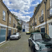
Lees Place is a part-cobbled through road off Park Street in Westminster, running directly in line with Wood’s Mews, another original/ surviving Mews. There are 23 properties in the Mews, used for residential purposes.
A high explosive bomb fell directly onto the Mews in World War II. When the London Poverty Maps were published, the area was determined as having fairly comfortable households with good ordinary earnings.
Lees Place is part of Westminster City Council’s Mayfair Conservation Area. First designated in 1969, it derives its name from a fair held in the month of May in fields around the site of today’s Shepherd Market. The area is dominated by fashionable town-houses (and their mews) reflecting the history of English domestic architecture from the early 18th to the early 20th century.
The Mews has two, three and four storey buildings with mansard and parapet roof styles and plain brickwork facades. Some garages present remain intact whilst others have been converted. The buildings are surrounded by a cobbled and tarmacadam road surface and raised pavements.
Everchanging Nature
Formally called Lees Mews, the original purpose of the street was to provide stable/ coach house accommodation to the main houses in the surrounding area. Nowadays, the function of the properties is residential rather than commercial.
A few planning applications have been made before and since 2003 for alterations to properties, notably; roof extensions, the partial demolition of some properties and changes to the fenestration. Conservation Area controls now apply to new development in the Mews.
Similar Listings