Property Description
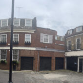
Ledbury Mews West is a cobbled cul-de-sac approached through an entrance under a building on Ledbury Road in the Royal Borough of Kensington and Chelsea, almost opposite Ledbury Mews North, another original/ surviving Mews and with a pedestrian through road to Laverton Place. It contains 14 properties used for residential purposes.
When the London Poverty Maps were published, the area was noted as having a mixture of comfortable living conditions with lower than average household salaries for the time. A high explosive bomb fell north of the Mews onto Artesian Road in World War II.
The Mews is part of Kensington’s ‘Pembridge’ Conservation Area. One of the earliest designations in 1969, the area has since been developed in the 19th Century and contains a wide variety of different building types; from Mews to terraces and semi-detached/ detached villas.
The two storey properties have a mansard and pitched roof styles and plain or painted brickwork facades. Parking is restricted along the cobbled road and there are raised party walls and wooden bressumers present.
Everchanging Nature
Originally the stable house accommodation for the main houses on the surrounding streets, the primary purpose of the Mews properties is now residential.
Before and since 2003 there have been a number of planning applications made for alterations to the properties in Ledbury Mews West; most notably roof additions, changes to the fenestration and the complete demolition of some existing properties.
Conservation Area controls now apply to new development in the Mews.
Similar Listings