Property Description
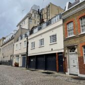
Drayson Mews is a cobbled through road off Holland Street in the Royal Borough of Kensington and Chelsea, leading to Hornton Place. Drayson Mews contains 35 properties used for residential and commercial purposes.
At some point between October 1940 and June 1941, a high explosive bomb fell onto Hornton Street, just east of the Mews. The Mews was noted as having comfortable living conditions with ordinary household earnings for the time when the London Poverty Maps were first published, though some houses in the area were noted being poorer in comparison.
The Mews is part of the ‘Kensington’ Conservation Area; the largest Conservation Area, covering 130 acres in total and named after the borough in which it is situated has a plethora of varying locations, from busy shopping streets to quiet Mews cul-de-sacs. The area was originally designated in 1970 and then extended over the next few years, up to most-recently, 1993 to include Kensington High Street.
The two storey properties have a variety of different facades and a mixture of roof styles surrounded by a cobbled road surface. There are raised party walls present and metal bressumers to be seen.
Everchanging Nature
Originally the stable/ coach house accommodation for the main houses on the surrounding streets, the primary purpose of the Mews properties is now both residential and commercial, in the form of working garages (Jaguar, automotive engineers, Drayson Garage Ltd.).
Before and since 2003 there have been a few planning applications made for alterations to the properties in the Mews; mainly additional storeys added at second floor or roof level. Conservation Area controls apply to any new development in the Mews.
Similar Listings