Property Description
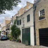
Montagu Mews North is a cobbled through road between Montagu Place and Crawford Street in Westminster, parallel to Clay Street and opposite Gloucester Place Mews, other original/ surviving Mews properties. There are 21 properties in the Mews, used for commercial purposes.

Between October 1940 and June 1941, a high explosive bomb is recorded falling onto Montagu Square, just north of the Mews. The area was noted as being fairly comfortable with good, ordinary household earnings when the London Poverty Maps were first published though some areas were deemed as being severely impoverished.
Montagu Mews North is a part of Westminster City Council’s Portman Estate Conservation Area. Situated in the boundaries of Marylebone, which was once covered with forest and marshland, the estate originally comprised about 270 acres and now contains a variety of buildings from different centuries, from many examples of Mews to the grand terraces of Bryanston Square and Montagu Square.
The Mews has two and three storey, plain and painted brickwork buildings with mansard roof styles. The buildings are surrounded by a cobbled road surface and parking is restricted.
Everchanging Nature
The original purpose of the Mews was to provide stable/ coach house accommodation to the main houses on Upper Montagu Street and Gloucester Place and the properties are still used commercially today.
A few planning applications have been made since 2003 for alterations to properties; mainly changes to the fenestration and the partial demolition of a Mews property. Conservation Area controls now apply to new development in the Mews.
Similar Listings