Property Description
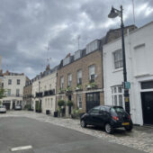
Eaton Mews West is a cobbled through road between Elizabeth Street and South Eaton Place in Westminster and is approached through its own arch. There are 12 properties in the Mews, used for both residential and commercial purposes and it runs directly in line with Boscobel Place, another original/ surviving Mews.
A high explosive bomb fell directly onto the Mews, meaning the properties had to be rebuilt as a result of the damage that occurred in World War II. When the London Poverty Maps were published, the area was determined as being fairly comfortable and having households with good ordinary earnings.
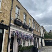
Eaton Mews West is part of Westminster City Council’s Belgravia Conservation Area. First designated in 1968, it was laid out as a fashionable residential area to the west of Buckingham Palace. There is a high degree of townscape uniformity and a formal layout based on a grid pattern. The area is predominantly residential with some shops on the edges. There are also a significant number of embassies, diplomatic buildings and institutional headquarters.
The two and three storey properties are a mixture of plain, painted and rendered brickwork and display mansard roof styles. There are both intact and converted garages present, surrounded by a cobbled road surface. Some of the properties and the archway at the eastern end of the Mews are registered listed buildings.
Everchanging Nature
The original purpose of Eaton Mews West was to provide stable/ coach house accommodation to the main houses on Eaton Square and Chester Square. Now, it is predominantly used for residential purposes although some commercial activity still remains in the form of offices.
Many planning applications have been made since 2003, most notably; basement excavations and conversion of garages to residential quarters. Conservation Area controls now apply to new development in the Mews.
Similar Listings