Property Description
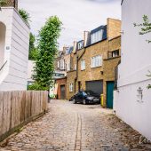
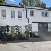
Cochrane Mews is a cul-de-sac off Circus Road in Upper-Westminster. The Mews contains 11 properties, only one of which is an original Mews. The properties are used for both commercial and residential purposes.
Between October 1940 and June 1941, a high explosive bomb is recorded falling onto Kingsmill Terrace, north-west of the Mews. The area was noted as having a mixture of fairly comfortable living conditions with good, ordinary household earnings up to middle-class stature when the London Poverty Maps were first published.
Cochrane Mews is part of Westminster Council’s St John’s Wood Conservation Area, one of Westminster’s biggest Conservation Areas located in the northern extremity of the City. Designated a Conservation Area in 1968, St John’s Wood has an overall low-density townscape with wide tree-lined streets. Importance is placed on generous gardens, trees and greenery, with smaller pockets of terraced housing and mansion blocks.
The Mews consists of one and two storey properties with a plain brickwork facade and a mixture of mansard and parapet roof styles. The garages present have been converted and are surrounded by a tarmacadam road surface.
Everchanging Nature
Originally the coach house accommodation for the main properties in St John’s Wood High Street, the buildings are now used for both commercial and residential purposes. There have been a few planning applications made prior to and since 2003; most of the original Mews properties have been replaced and only one remains. Conservation Area controls now apply to any new development in the Mews.
Similar Listings