Property Description
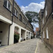
Charles Lane is a cobbled through road between St John’s Wood High Street and Charlbert Street in Upper-Westminster. Containing 32 properties used for residential purposes, the Mews runs roughly east-west and is close to Regent’s Park.
In World War II, a high explosive bomb is recorded falling onto Kingsmill Terrace, not far from the Mews. When the London Poverty Maps were published, the area was described as being relatively poor compared to the normal, standard household earnings at the time.
Charles Lane is part of Westminster Council’s St John’s Wood Conservation Area, one of Westminster’s biggest Conservation Areas located in the northern extremity of the City. Designated a Conservation Area in 1968, St John’s Wood has an overall low density townscape with wide tree-lined streets. Importance is placed on generous gardens, trees and greenery, with smaller pockets of terraced housing and mansion blocks.
Charles Lane is a less complete mews compared to others in the area, containing buildings with additional storeys and replacement metal garage doors. There is a mixture of different roof styles across the properties and a painted and rendered facade.
Everchanging Nature
The original purpose of the Mews was to provide stabling for the surrounding properties on St John’s Wood Terrace and Allitsen Road but nowadays they are predominantly used for residential purposes. There have been a few planning applications made since 2003, mainly minor changes to the fenestration and other aspects of the exterior to the properties. Conservation Area controls now apply to any new development in the Mews.
Similar Listings