Property Description
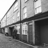
Welbeck Way is a through road with a cul-de-sac section, off Wimpole Street in Westminster. The Mews contains 13 properties used for residential purposes.
In 1940, a high explosive bomb is recorded falling somewhere on Welbeck Street, to the north-west of the Mews. When the London Poverty Maps were published, the area was noted as having comfortable living conditions with average household salaries.
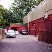
Welbeck Way is situated to the south of the Harley Street Conservation Area in Westminster. First designated in 1968, the area is now dominated by terraced houses of different periods and different levels of social status. It retains a substantial medical presence, whilst offices predominate to the eastern edges.
The two storey properties in the Mews have a plain or painted brickwork facade and gable and pitched roof styles. There are partial raised pavements surrounded by a tarmacadam road surface.
Everchanging Nature
There have been many planning applications made for alterations to the Mews properties in Welbeck Way prior to and since 2003, the most notable being; the complete demolition and rebuilding of some of the properties. Conservation Area controls apply to any new development being carried out in the Mews.
Similar Listings