Property Description
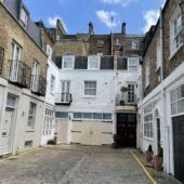
Queen’s Mews consists of 2 cobbled cul-de-sacs both sides of Salem Road in Westminster. There are a total of 35 properties in the Mews, used for residential purposes.
A high explosive bomb fell onto Porchester Gardens, just above the north-east end of the Mews in World War II. When the London Poverty Maps were published, the area was determined as being normal in comparison to the standard household salaries at the time, with comfortable living conditions.
Queen’s Mews is part of Westminster City Council’s Bayswater Conservation Area. Developed over the space of about 70 years, the townscape is uniform despite being composed of several distinct areas and is made up of a regular composition of streets and squares in an Italianate style. An important aspect of the street pattern are the several mews, some quite intimate and others so large that they appear to be a development of their own. The contrast of scale provided by these mews is a crucial aspect of the overall area’s character.
The two and three storey buildings have a variety of mansard and parapet roof styles with some intact garages surrounded by a cobbled road surface.
Everchanging Nature
The original purpose of the Mews was to provide stable/ coach house accommodation to the main houses on Prince’s Square and Porchester Gardens. Now, it is predominantly used for residential purposes.
Very few planning applications have been made before and since 2003 for alterations to the properties, mainly concerning changes to the fenestration and the addition of a new storey. Conservation Area controls now apply to new development in the Mews.
Similar Listings