Property Description
Montpelier Walk is a through road between Cheval Place and Montpelier Square in Westminster, Cheval Place being another original/ surviving Mews street. There are 53 properties in the Mews, used for both commercial and residential purposes.
Between October 1940 and June 1941, a high explosive bomb is recorded falling onto Brompton Square, not far from the Mews. The area was noted as being fairly comfortable with a good standard of living when the London Poverty Maps were first published.
Montpelier Walk is part of Westminster City Council’s Knightsbridge Conservation Area. Designated in 1968, the area relates strongly to Queen’s Gate Conservation Area in Kensington and Chelsea and contains large-scale cultural and educational institutions such as the Royal Albert Hall. The western half of the area is dominated by a late Victorian cultural complex and mansion blocks whilst the east has residential areas of leafy squares and intimate terraces.
There are also several mews within the conservation area, particularly to the east and south. These are characterised by their intimate scale and are generally two storeys in height and relate to the plot width of the principal building with which they are associated.
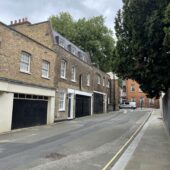
The Mews has two and three storey buildings with a variety of mansard and parapet roof styles and painted brickwork facades. The buildings are surrounded by a tarmacadam road surface, raised pavements and have restricted parking.
Everchanging Nature
The original purpose of the Mews was to provide stable/ coach house accommodation to the main houses on the surrounding street and today they are used for a mixture of commercial and residential activity.
A fair amount of planning applications have been made since 2003 for alterations to properties, notably; basement excavations, roof extensions and the complete demolition of some original Mews properties. Conservation Area controls now apply to new development in the Mews.
Similar Listings