Property Description
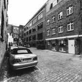
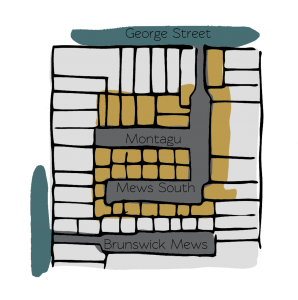
Montagu Mews West is a cobbled cul-de-sac off George Street in Westminster, opposite Montagu Mews South, another original/ surviving Mews street. There are 23 properties in the Mews, used for residential purposes.
Between October 1940 and June 1941, a high explosive bomb is recorded falling onto Great Cumberland Place, just below the Mews. The area was noted as being fairly comfortable with good, ordinary household earnings when the London Poverty Maps were first published.
Montagu Mews West is a part of Westminster City Council’s Portman Estate Conservation Area. Situated in the boundaries of Marylebone, which was once covered with forest and marshland, the estate originally comprised about 270 acres and now contains a variety of buildings from different centuries, from many examples of Mews to the grand terraces of Bryanston Square and Montagu Square.
The Mews has two and three storey buildings with mansard and parapet roof styles and a variety of different materials and styles used in the facade. The buildings are surrounded by a cobbled road surface and parking is restricted.
Everchanging Nature
The original purpose of the Mews was to provide stable/ coach house accommodation to the main houses on Montagu Square but today the properties are mainly used residentially.
A few planning applications have been made since 2003 for alterations to properties; mainly changes to the fenestration and roof extensions. Conservation Area controls now apply to new development in the Mews.
Similar Listings