Property Description
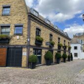
Ladbroke Walk is a cobbled through road off Ladbroke Grove in the Royal Borough of Kensington and Chelsea, leading to Ladbroke Terrace. It contains 29 properties used for residential purposes.
When the London Poverty Maps were published, the area was noted as having comfortable living condition with higher than average, middle class household salaries for the time. A high explosive bomb fell north of the Mews onto Ladbroke Terrace in World War II.
The Mews is part of Kensington’s ‘Ladbroke’ Conservation Area; designated in 1969, it is situated in the Notting Hill area of North Kensington and predominantly contains Victorian classical architecture around large garden squares.
The two and three storey properties have a mixture of different roof styles and rendered or painted brickwork facades. Parking is restricted along the cobbled road, with partial-raised pavements.
Everchanging Nature
Originally the stable house accommodation for the main houses on the surrounding streets, the primary purpose of the Mews properties is now residential.
Before and since 2003 there have been a number of planning applications made for alterations to the properties in Ladbroke Walk; most notably changes to the fenestration, roof extensions, garage conversions and the complete demolition of an existing Mews house in 2002.
Conservation Area controls now apply to new development in the Mews.
Similar Listings