Property Description
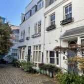
Queensdale Place is a part-cobbled cul-de-sac off Queensdale Road (opposite Addison Place, another original/ surviving Mews) in the Royal Borough of Kensington and Chelsea. It contains 28 properties used for residential purposes. It is located on the site of an original Mews but has been re-developed to a degree that it no longer contains any surviving Mews properties.
In 1940, a high explosive bomb is recorded falling onto Royal Crescent, just south-west of the Mews. When the London Poverty Maps were published, the area was noted as having a mixture of comfortable living conditions with average household salaries, to poorer residences.
The Mews is part of Kensington’s Norland Conservation Area; first designated in 1969, it contains Royal Crescent, Norland Square and St. James’s gardens. Building of the area began in the 1840’s and was completed just fifteen years later. It contains linked terraces and is largely urban in style.
The two storey properties have mansard roof styles and a mixture of painted brickwork or rendered facades. Parking is allocated/restricted along the cobbled, paved and tarmacadam road and there are raised pavements.
Everchanging Nature
Before and since 2003 there have been many planning applications made for alterations to the properties on Queensdale Place, most notably; roof extensions, additions of balconies and the complete demolition of certain properties.
Conservation Area controls now apply to new development in the Mews.
Similar Listings